Six mile Hike 7/19/2016
Humbug Mountain in Coast Range

Hike Descritping
Six miles with 1100 feet elevation
Trailhead is 3.5 miles passed Camp 18 off Hwy 26.
This hikes gives great views including a view of South Saddle Mountain.
The hike is on an abandoned logging road.
The hike provides a rare close-up view of Saddle Mountain
as well as a 360 degree coastal panorama.

After hiking the Humbug Mountian trail
It was still early so
Joan and I did a couple of mile hike
on the Four Country Point trail.


The group assembles
at the starting gate

Our leader
on the trail


Joan on the trail


on the
trail


Views of
Saddle Mountain


Views along the trail
and at the top of the mountain


Hike on the
Four Points Trail


Four counties Meet
at this point
Clatsop
Columbia
Tillamook
Washington


Flowers we Saw


Buttercup
probably Creeping buttercup
(Ranunculus repens)


Foamflower
(Tiarella trifoliata


Foxglove
(Digitalis)


Monkey Flower
(Mimulus)


Self-Heal
(Prunella vulgaris)


Ragwort
(Senecio jacobaea or Jacobaea vulgaris)

other names: common ragwort, hysterical weed,
ragwort, stagger wort,
staggerwort, tansy butterweed, tansy ragwort, stinking willie,
stinking willy, St James' wort,
yellow ragwort

Ragwort is poisonous invasive species
But no problem for humans becasue you
would have to eat lots for it to be a problem

Horses will not eat the plant becasue it tastes bad
but if it grows in a hay field and is cut with the hay
bad taste is lost when dried, but poison remains.


Hawksbeard
(Crepis capillaris)
or Hawksweed
an Invasive species

The name "hawkweed" comes from a belief by the ancient Greeks that hawks would tear apart a plant and
wet their eyes with the juice to clear their eyesight. .


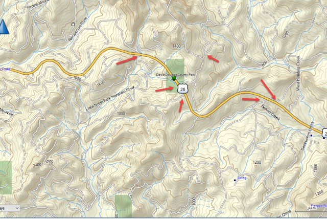
Maps


Directions to Trailhead

1) Take Hwy 26 toward the Coast to Camp 18
2) Go about 3.5 miles passed Camp 18 to a sign that gives elevation
       Sign is at crest of the mountain
3) Rooad to trailhead is on the right just passed the elevatin sign.


Click on a thumbnail to enlarge aaaaaaa

1.

2.

3.

4.

5.

6.

7.

8.

9.

10.

11.

12.

13.

14.

15.

16.

17.

18.

19.

20.

21.

22.

23.

24.

25.

26.

27.

28.

29.

30.

31.

32.

33.

34.

35.

36.

37.

38.

39.

40.

41.

42.

43.

44.

45.

46.

47.

48.

49.

50.

51.

52.

53.

54.

55.

56.

57.

58.

59.

60.

61.

62.

63.

64.

65.

66.

67.

68.

69.

70.

71.

72.

73.

74.

75.

76.

77.

78.

79.

80.

81.

82.

83.

84.

85.

86.

87.

88.

89.

90.

91.

92.

93.

94.

95.

96.

97.

98.

99.

100.

101.

102.

103.

104.

105.

106.

107.

108.

109.

110.

111.

112.

113.

114.

115.

116.

117.

118.

119.

120.

121.

122.

123.

124.

125.

126.

127.

128.